


Geocam Free
Descrizione di Geocam Free
Geocam by Wazar is the leading geophoto and video application for Android. It uses augmented reality to show on top of your camera a layer of geographical information such as Compass orientation, GPS position and different phone inclinations like a theodolite optical instrument.
What you can do with Geocam:
* Geo-Pictures: photos that have an extra layer of geographical data such as GPS position, compass orientation, pitch, roll, altitude, etc. This data is added into the EXIF metadata and can selectively be drawn on images as an overlay. You can see all you pictures on Google Maps or on Google Earth on your personal computer with the export feature. You can share those albums with anyone who can run Google Earth.
* Geo-Videos (Pro only): the first and only app to let you record videos with an embed layer of geographical data. A useful addition to pictures. With Geocam Studio (available on geocam.wazar-apps.com), customize and export these videos and share them.
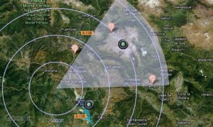
* Bearings: Geocam is an accurate measure tool. It shows your compass orientation (choose between magnetic or geographic North), your inclination and elevation with readable cursors (like a cockpit HUD). It can be used in terrain mapping, on a glide, sailing, mountain biking...
* Geo-Caching: prepare a list of key places in an area and view them with your camera on augmented reality: name, distance. You will not require a data connection offline so it can be used when hiking abroad, when visiting another city... This will help you make sure you are going in the right direction and give you remaining distance. You can also add markers during your hike with the "Add here" option, for example to flag the base camp, a water source, or anything interesting you find on your way.
* Measurements: Evaluate the distance to any object with the triangulation feature. You can also measure its height once the distance is known. This is not done by showing any unreadable cursor on the screen, but with mathematical formulas. Choose between metric and imperial measure systems.
Geocam supports extensive customisation including:
* Selecting which indicators to display on the HUD and whether to save them or not on pictures
* Metric and imperial systems
* GPS Formats: Decimal degrees, degrees/minutes/second, MGRS, UTM
* True north or magnetic north
* Degrees or Mils compass readings
* Percentage or degree slopes
* Calibrating "zero" pitch and roll to custom values to measure differences
* Different themes including a "cockpit" style or a "hi-vis" style
This is a free edtition, and with Geocam Pro, you get:
* No Ads
* Record and playback augmented video. This is a powerful tool in addition to Geophoto to record the topology of any area for further reference, as you can add your own audio commentary. Augmented video is an exclusivity of Geocam by Wazar.
* Export KMZ files to Google Earth, to display your pictures and markers in their original location and orientation, and share them easily.
IMPORTANT NOTE: If you are facing an issue, we cannot help you if you only leave a review. Do get it touch by email so we can hep you. We do reply to all emails and regularly push out fixes to reported problems. By all means please do get in touch if you are experiencing difficulties.
GeoCam dal Wazar è l'applicazione leader geophoto e video per Android. Esso utilizza la realtà aumentata per mostrare sulla parte superiore della fotocamera uno strato di informazioni geografiche come l'orientamento della bussola, posizione GPS e diverse inclinazioni telefono come uno strumento ottico teodolite.
Che cosa si può fare con GeoCam:
* Geo-Immagini: foto che hanno un ulteriore livello di dati geografici come la posizione GPS, l'orientamento bussola, beccheggio, rollio, altitudine, ecc Questi dati vengono aggiunte metadati EXIF e può essere selettivamente disegnato su immagini come una sovrapposizione. Potete vedere tutti voi le immagini su Google Maps o su Google Earth sul proprio personal computer con la funzione di esportazione. È possibile condividere quegli album con chiunque in grado di eseguire Google Earth.
* Geo-Video (Pro): la prima e unica applicazione per farvi registrare video con uno strato embed di dati geografici. Un utile aggiunta alle immagini. Con GeoCam Studio (disponibile su geocam.wazar-apps.com), personalizzare ed esportare questi video e condividerli.
* Cuscinetti: GeoCam è uno strumento di misura accurata. Essa mostra l'orientamento bussola (scegliere tra Nord magnetico o geografico), la vostra inclinazione ed elevazione con i cursori leggibili (come una cabina di pilotaggio HUD). Può essere utilizzata nella mappatura del terreno, su un glide, vela, mountain bike ...
* Geo-caching: preparare un elenco di luoghi chiave in una zona e visualizzarli con la fotocamera sulla realtà aumentata: nome, distanza. Non sarà necessaria una connessione dati in linea in modo che possa essere utilizzato durante le escursioni all'estero, quando si visita un'altra città ... Questo vi aiuterà a fare che si sta andando nella direzione giusta e vi darà la distanza rimanente. È inoltre possibile aggiungere i marcatori durante l'escursione con l'opzione "Aggiungi qui", ad esempio per la bandiera del campo base, una fonte di acqua, o di qualcosa di interessante che trovate sul vostro cammino.
* Misure: Valutare la distanza da qualsiasi oggetto con la funzione di triangolazione. È inoltre possibile misurare la sua altezza, una volta la distanza è nota. Questo non è fatto mostrando alcun cursore illeggibili sullo schermo, ma con formule matematiche. Scegliere tra i sistemi di misura metriche e imperiali.
GeoCam supporta un'ampia personalizzazione tra cui:
* Selezione quali indicatori visualizzare sul HUD e se salvare o meno sulle immagini
* Metriche e sistemi imperiali
* Formati GPS: Gradi decimali, gradi / minuti / secondi, MGRS, UTM
* Vero nord o nord magnetico
* Gradi o Mils letture della bussola
* Percentuale o laurea da sci
* Taratura "zero" beccheggio e rollio per valori personalizzati per misurare le differenze
* Diversi temi tra cui uno stile "cabina di pilotaggio" o uno stile "hi-vis"
Questa è una edtition gratuito, e con GeoCam Pro, si ottiene:
* Nessuna pubblicità
* Registrazione e riproduzione video aumentata. Si tratta di un potente strumento in aggiunta alla Geophoto per registrare la topologia di una zona per ulteriore riferimento, come è possibile aggiungere il proprio commento audio. il video Aumentata è una esclusività della GeoCam da Wazar.
* Esportare file KMZ per Google Earth, per visualizzare le immagini ei marcatori nella loro posizione e orientamento degli originali, e condividerli facilmente.
NOTA IMPORTANTE: Se siete di fronte un problema, non possiamo aiutare se si lascia solo una recensione. Non farlo toccare via e-mail in modo che possiamo hep voi. Noi rispondiamo a tutte le email e regolarmente spingere fuori correzioni per i problemi segnalati. Con tutti i mezzi si prega di mettersi in contatto se si verificano problemi.
Geocam Free - Versione 5.34
(10-04-2020)Geocam Free - Informazioni APK
Versione APK: 5.34Pacchetto: com.mywayUltima versione di Geocam Free
Altre versioni


App nella stessa categoria
 3.694.324.074.013.674.41
Potrebbe piacerti anche...